Wednesday, December 11, 2013

"Ring of Fire" activity


A strong magnitude 6.3 hits near Indonesian cities.  Adaption Methods would include the forecasting and warning system for such an event as well as determining if a tsunami is to follow.  Neither Japan of Indonesia has issued a tsunami warning.
Map showing location of earthquake

 This shallow earthquake hit at about 351 kilometers east-northeast of the East Timor capital Dili according to the US geologic survey.  It was lucky enough that the quake hit in a remote area where there is little likelihood of too much damage, injuries or casualties. Shaking was felt in nearby cities but it was not damaging.  Being on the Ring of fire, Indonesia often gets seismic as we as volcanic activity caused by the colliding of plates. 
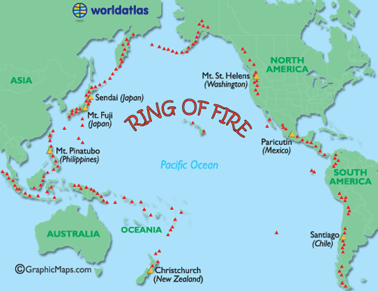

http://www.worldatlas.com/aatlas/infopage/ringfire.htm

Now check out that ring of fire^^^

Thursday, December 5, 2013

Fukushima Nuclear Leak

Looks like Japan is having some mitigation issues with their whole nuclear power plant spill issue.  There is an estimated 300 tonnes of radioactive material released into our ocean each day because of the tsunami that hit Fukushima in March of 2011.  This is soon to be a world issue affecting the worlds shorelines and fish but Japan is STILL denying help.

http://articles.latimes.com/2011/mar/28/science/la-sci-japan-reactor-damage-20110328

Their plans on stopping the flow of radioactive material to the ocean aren't looking too spectacular either.  The giant ice wall that would be able to freeze anything that tried to pass it would be far too costly.  Another consideration is to dump tanks with the lowest percent of radioactive material into the ocean to fill them up with the most radioactive material.  Still a lot of brainstorming needs to be had. This is some seriously scary stuff.

http://www.rawstory.com/rs/2013/09/05/japan-nuclear-agency-says-fukushima-water-leak-risk-exaggerated/


Tuesday, December 3, 2013

Snow storms in the US

Looks like we have some storms rolling in throughout the USA.
Snow storms are coming in from Utah up to South Dakota.  Rain storms are throughout South Carolina and Georgia as well as Michigan. 


The Midwest will be experiencing a lot of snow coming up as well as extremely cold temperatures.  There has already been 30 inches of snow recorded.  Dangerous road conditions is the hazard caused.

It's even forecasted that California could possibly be getting snow around San Francisco if the snow goes further than what is in the map below. 
Times like these you can really see good examples of adaption.  We have a great warning system that shows where the snow is likely to hit so we can all prepare.  For those in California and southern states, snow is a huge deal and they are likely to keep off the roads and cancel school for snow storms.  Up in the mid-west, we have cars built to handle these conditions and we'll have snow plows out right away.

Post Philippines Typhoon

Behavior Paradigm:
Catagory 5 Super Typhoon
The people of the Philippines were able to predict where the Typhoon was likely to hit and therefore could evacuate 800,000 people.

The Philippines has had 182 disasters since 2002 but this was the most devastating typhoon since 1990.  And it was the largest typhoon/cyclone that hit land to be recorded and hit record wind speed.


Why was this one so large?  Global climate change?!?!?!?!

The typhoon hit where there was a large density of people with poorly constructed houses causing a lot of destruction and deaths.  Even though they evacuated many people and are used to disasters, the relief efforts had a hard time getting to them because of damage to transportation.  Evacuation areas also were low on supplies and food leaving many people hungry for days.


Now the Philippines is recovering in a mess filled with corpses, flooded villages, broken houses, and crops that have been uprooted.  Many of the people are left without jobs as well.  There are efforts to help rebuild the damaged areas of the Philippines and start to put up defenses to help prevent some destruction for future events.

Tuesday, November 12, 2013

Philippines Typhoon

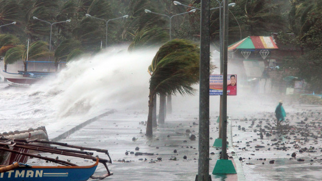
Just last week, the Philippines was struck by a massive Typhoon.  The storm's winds were at 195 mile per hour with wind gusts up to 235 mph.  The storm destroyed 70-80% of structures in it's path.  Some cities are left almost completely under water.
An estimated 10,000 people were killed by the last week's Typhoon in the Philippines, that number could increase once rescuers reach the remote villages. Hundreds of thousands of people have been displaced.
Destroyed houses hit by Typhoon Haiyan in the town of Guiuan in Eastern Samar province, central Philippines on 11 November 2013
http://www.bbc.co.uk/news/world-asia-24894529

Mitigation: Many people were left waiting for rescue without food, water or medicine.  Even people who did make it to shelter have been there without food. The rescue efforts were hindered because of the damage of transportation methods.  Roads, bridges and airports have either been destroyed or covered in wreckage.

 90 U.S. Marines are on their way to provide assistance.  UNICEF is rushing emergency supplies to the Philippines.  Many other Countries are sending in more help and relief efforts are taking donations.

Survivors walk under a fallen electric post after super Typhoon Haiyan battered Tacloban city, central Philippines November 10, 2013. REUTERS-Romeo Ranoco
http://www.reuters.com/article/2013/11/10/us-philippines-typhoon-idUSBRE9A603Q20131110

Adaption: Warnings for the storm were not given in time for the Philippines but they were able to predict that the storm would be headed to Vietnam/Southern China.  The warnings made it possible for many people to evacuate before the storm hits.


http://www.cbsnews.com/8301-202_162-57611886/philippines-typhoon-victims-beg-for-help-as-aid-slowly-trickles-in/

The map below shows the path of the typhoon.  The red areas represent destroyed areas while the yellow is the heavily damaged areas.  Areas in white have unknown data at this time.


Monday, November 11, 2013

Granite peak snow

Kind of a funny weather hazard that happened in Wausau the other day.  The Granite Peak Ski Hill started making snow and because of just the right atmospheric conditions, the snow made it over to my parents neighborhood.  This doesn't seem like such a light snow could be hazardous but because it wasn't cold enough for the snow to stay snow, it made for very slippery conditions.

Several car accidents happened because of the icey conditions resulting in detoured roads.  According to some drivers, the detours became jammed because of two additional car accidents.

 The map below shows where Rib Mountain's Granite Peak Skill is compared to the area affected by the snow.

The general manager of the ski hill says that she recieves many complaints each year about the man-made snow causing slippery road conditions.  Seriously complainers, The hill is Wausau's biggest tourist attraction and creates additional hobbies for the locals.  We live in Wisconsin, Iced roads is something you need to learn to deal with!

Tuesday, October 22, 2013

Toxic Smog- China

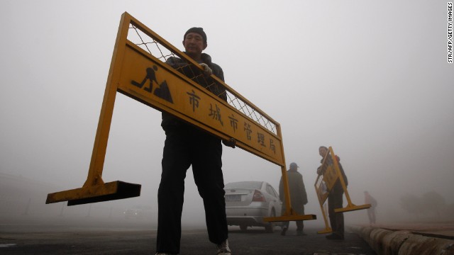
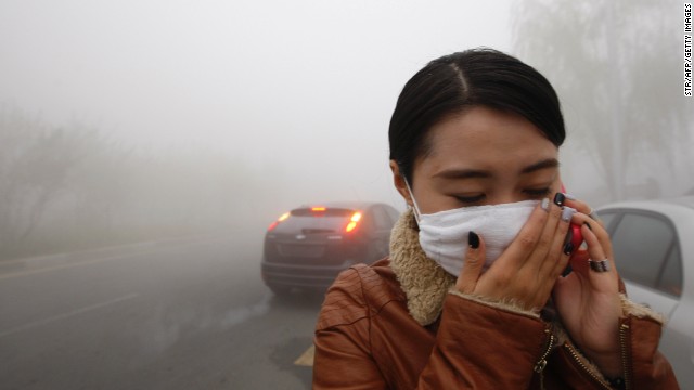
A heavy, Toxic smog is covering NE China.  The smog has caused many schools to close down, flights have been delayed, trains and buses stopped running and it has caused some highway closings.  It is expected that the fog will worsen within the next 24 hours bringing visability down to 100 meters, in a few spots the visability had gone down to 20 meters. People have been buying protective masks to keep from inhaling the bad air. "My mask turned black after I wore it for half an hour," said a citizen of Harbin.
A workman carries a road barrier on a Harbin street on October 21.


This hazard is technological because it is due to air pollutants caused by humans. The big pollutant emissions are from coal-burning, vehicle exhaust and the burning of crop stalk on the outskirts, according to environmental authorities in Heilongjiang.

There isn't much protection against something like this without stopping constant pollution.  The defense is mainly adaption because they had masks ready for sale.  They are also able to warn the rest of the country that are in danger of the smog to roll in.  Other protective measures include keeping people indoors(especially the elderly or young children).

A woman walks in the Harbin smog October 21. "We can smell the smoke in the air," one man told CNN.


http://www.newsbullet.in/world/52-more/46748-china-city-shutdown-due-to-hazardous-smog

http://www.cnn.com/2013/10/22/world/asia/china-smog-lingers/

Tuesday, October 15, 2013

Philippines Earthquake

A Philippines Earthquake hit this morning around 8am.  It was a magnitude 7.1 causing 93 deaths.  The roads and bridges were down and it made for some difficult rescue efforts.

Residents walk along huge cracks in a road after an earthquake struck Bohol province, central Philippines, October 15, 2013.
http://www.bbc.co.uk/news/world-asia-24530042

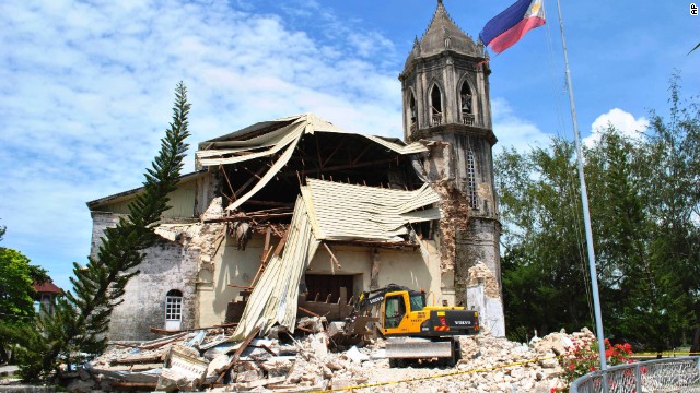
Just as we talked about today there was some developemental pressure in the road/bridge structures in the area as well as housing, government buildings, schools, hospitals and some of their well known churches.  The structures clearly weren't built to withstand such an Earthquake even though the area is prone to Earthquakes.  The lucky thing about the earthquake hitting today was that it is the Muslim festival of Eid al-Adha so schools and offices were closed which had saved many lives.

A crane sifts through the rubble of Our Lady of Assumption Parish Church in Dauis on October 15.
http://www.cnn.com/2013/10/14/world/asia/philippines-earthquake/

September 7th of 2012 there was a magnitude 6.9 earthquake that caused similar damage as you can see in the photo below.


http://www.cnn.com/2013/10/14/world/asia/philippines-earthquake/
http://www.weather.com/news/72-magnitude-earthquake-strikes-phillipines-least-4-dead-20131014
http://www.bbc.co.uk/news/world-asia-24530042

Tuesday, October 8, 2013

Japan Nuclear Leak

fukushima
http://america.aljazeera.com/articles/2013/10/6/japan-asks-for-worldshelponfukushimaleaks.html
 Japan had a major Nuclear power plant leak about 2 years ago caused by a damaging earthquake. Japanese officials acknowledge that nuclear waste has been flowing into the pacific ocean for the last two years.  Japan is really hoping for some overseas help which would be a good idea because the radioactive leak could potentially spread to our shore.

The flow started at spilling about 300 tons a day.  The biggest health concern is the leak infecting the fish near the area.

Right now to treat this they have treated water in the tanks to remove cesium which is one of the more harmful radioactive elements.  The Japanese government will be funding the building of an ice wall to prevent the spreading of toxic materials to the pure waters.

This was a technological hazard because it was caused by human technologies.  There is nothing we can do to prevent an Earthquake but they could have taken measures to prevent this amount of damage.  Nuclear power has some harsh effects when mistakes are made which is why it's always good to be extra cautious.  Clearly Japan didn't go above and beyond while trying to keep the ocean safe from their radioactive chemicals.  Knowing that Japan is prone to Earthquakes they could have taken better procaution and built up this area better and away from water.


Graphic showing how the storage tank leaked
http://www.foxnews.com/world/2013/09/04/look-at-radioactive-water-leaks-at-japan-fukushima-nuclear-power-plant-and/

http://america.aljazeera.com/articles/2013/10/6/japan-asks-for-worldshelponfukushimaleaks.html

http://www.bbc.co.uk/news/world-asia-24377520

Friday, September 20, 2013

Yosemite

I won't be reporting on any hazards for the next week because I'll be going to Yosemite National Park!!! My Yosemite tab will have information and pictures from my trip when I return!

Tuesday, September 17, 2013

Mexico Duel Storms

At least 40 people have been killed in the deadly storms happening on both coasts of Mexico. 60,000 tourists are stranded in Alcapulco.  The storms triggered flash floods and land slides.  On one of the road closings there was a bus accident caused by a landslide killing 12 people.  It's not typical that Mexico gets hit by both a tropical storm and a hurricane at the same time.  Having back-up ready for one storm is much different than preventing distruction on two.


http://www.accuweather.com/en/weather-news/ingrid-manuel-mexico-hurricane/17793800
Above is a damaged van in a low-income neighborhood in Chilpancingo, Mexico after a landslide yesterday.


http://www.theguardian.com/world/2013/sep/17/two-storms-mexico-deaths-tourists-stranded

http://www.bbc.co.uk/weather/features/24134494

Thursday, September 12, 2013

Severe Thunderstorms


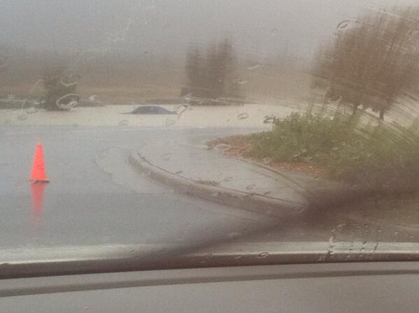
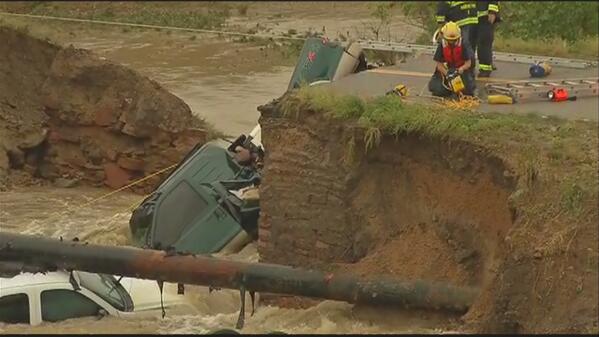
We have some severe storms going on heading to the North West. There are many flood watches in act throughout the west.  Colorado has a flood emergency right now involving closed streets, evacuations, mudslides and 2 deaths so far. The Office of Emergency Management in Boulder is reccomending evacuation for habitants in low-lying areas. Jamestown had reported the collapse of houses.

Embedded image permalink
https://twitter.com/es_hamilton/status/378160161921064960/photo/1

Above is a twitter update of the flooding in Aurora, CO.

Embedded image permalink
https://twitter.com/DenverChannel/status/378148295186464768/photo/1

Above you can see the damage near Hwy 287

Metro Area
http://www.thedenverchannel.com/weather/radars

There is a radar picture of the moisture coming through.
Denver's weather service is hoping for drier conditions beginning monday.

http://www.thedenverchannel.com/weather/radars
http://www.weather.com/news/weather-severe/colorado-flooding-live-updates-boulder-denver-20130912

Thursday, September 5, 2013

Yosemite Rim Fire

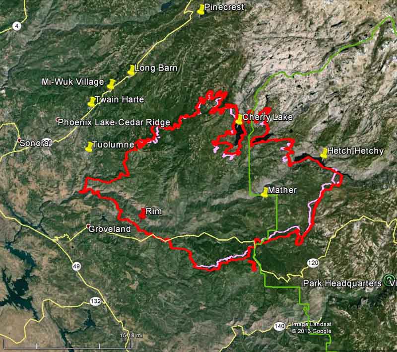
This fire in Yosemite had started around 3:15pm August 17th, 2013.  The fire had started near the Groveland District and is now at about 237,341 Acres.

This is a Picture of the location of fire spread:


The cause for the fire is still under investigation.  Of course with everything that is "still under investigation," there has to be someone jumping to crazy conclusions.  Local fire Chief McNeil was speculating that the fire was likely to be caused by illegal marijuana growers.  Jerry Snyder of the U.S. Forest Service says the area doesn't have the desirable water source to attract such plantations to the area; there has also been no evidence of marijuana growth in that area.  Snyder explains things like an illegal campfire or steep areas causing a spark by falling and collision of rocks could be to blame. Snyder says that lightning as causation is ruled out.

Currently there is around 4,000 people working on putting out the fire.  It is 80% contained and expected to be fully contained by September 20th (Just in time for my research trip to the area on the 21st!) 


The Rim Fire right now ranks as the 4th largest in the state's history.  According to East Country Magazine, 11 homes have been burned and thousands more are threatened.